|
|
|
|
| Missing In Action (MIA) | Prisoners Of War (POW) | Unexploded Ordnance (UXO) |
| Chronology | Locations | Aircraft | Ships | Submit Info | How You Can Help | Donate |
|
   USAAF 1943 |
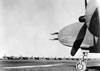
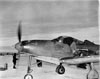
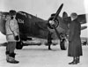
Location Lat 64° 30' 44N 165° 26' 43W Nome Airfield is located at 37' above sea level to the west of Nome in Alaska in the United States. Also known as Nome Field. Today known as Nome Airport. Construction Nome Airfield was to be built prewar by the Civil Aeronautics Authority and was instead undertaken by the U.S. Army. On July 23, 1941, U.S. Army engineers began construction of an emergency airfield that was expanded for military use. Wartime History On September 3, 1941 a U.S. Army garrison of 9 officers and 221 enlisted men arrived to protect the Nome base. During the Pacific War, Nome Airifeld was used to by military planes to patrol the Bearing Sea and as an emergency airfield. Also, it was part of the U.S. to USSR (Russia) ferry route for lend-lease aircraft. Units based at Nome 54th FG, 56th FS, 57th FS (P-39) Harding Field arrives June 20 - Oct 20, 1942 departs Elmendorf Today Still in use today as Nome Airport as a civilian airport with two intersecting runways. The first oriented 21/03 measures 5,576' x 150' surfaced by asphalt. The second was oriented 28/10 measures 6,001' x 150' surfaced by asphalt. Airport codes: FAA: OME / ICAO: PAOM / IATA: OME. Contribute
Information Last Updated
|
Map Fallingrain Map Mapcarta View in Google Earth Photo Archive |
| Discussion Forum | Daily Updates | Reviews | Museums | Interviews & Oral Histories |
|